
Top 5 Jurassic Coast Walks
Five of Your Favourite Walks Along the Jurassic Coast
Ninety-six miles of towering cliff faces, sparkling bays and nature reserves, the Jurassic Coast remains one of the world’s most stunning natural heritage sites. This majestic landscape, hemmed by undulating cliff paths, attracts walkers from far and wide, all of them captivated by the wends of this prehistoric corridor.
We always love hearing about all your wonderful adventures along this stretch of coastline, from the stories you tell or the photos you share. Here are five of your most memorable Jurassic Coast walks the whole family can enjoy…
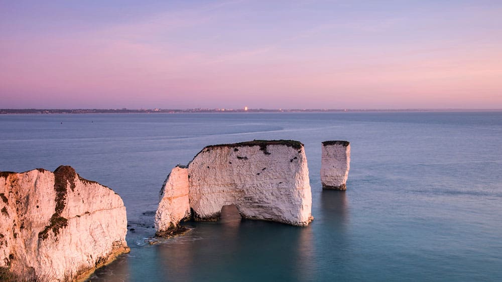
Old Harry Rocks
Spectacular views of the chalk sea stacks that glint like giant teeth on the mouth of Studland Bay
Duration: 2 hours
Terrain: Easy-going
Distance: 3.5-mile loop (Map)
Dog-friendly: ✔
Start your walk in the idyllic Purbeck village of Studland, two miles from Swanage. From the Middle Beech National Trust Car Park (BH19 3AU), follow the bends of Manor Road past the Bankes Arms, an enchanting 16th century pub with its own meadow scattered with picnic tables. Pick up the South West Coast Path as it runs along the peninsula past ancient farmland, towards the twisting hazels of Studland Wood, which is always bathed in wild garlic during the spring.
Arriving at Handfast Point, you’ll be able to enjoy mesmerising views of Old Harry Rocks and the panorama beyond. These famous chalk white sea stacks were eponymously named after the notorious 14th century Poole pirate, Harry Payne, and remain one of Dorset’s most famous landmarks. Keep your eyes peeled for peregrine falcons in the skies overhead which can sometimes be seen hunting quarry while performing devastating aerial displays. This stunning part of the walk deserves some special attention, and many choose to sit back amid the wildflowers to watch the roaring sea swells pounding the stacks below.
Leaving the gulls mewing on Old Harry’s grassy tufts, it’s time to round the headland above the chalky cliffs known as “The Pinnacles” en route to Ballard Point. The return leg of this loop takes you back inland across the pastures of the Glebeland Estate, the tower of the Studland Church of St Nicholas peeping through the treetops and the village’s exquisitely stone-carved Saxon cross standing at the crossroads. With any luck, you’ll make it back in time for a pub lunch or an exploration of the beautiful lowland heaths of Studland Nature Reserve.
Golden Cap
Spectacular views of Charmouth Bay and Chesil Beach from the highest point on the southwest coast
Duration: 2.5 hours
Terrain: Some steep terrain
Distance: 4-mile loop (Map)
Dog-friendly: ✔
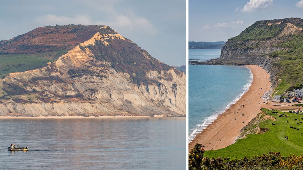
This perennially popular walk begins in the coastal hamlet of Seatown, following the South West Coast Path as it snakes its way toward the neighbouring village of Chideock. You’re headed for Golden Cap, the southwest coast’s highest peak boasting far reaching views across Lyme Bay and as far as the rugged wilds of Dartmoor. The waymarks will guide you across stubble fields, heathland, and woodland hangers, across bridges and through kissing gates, until the path steepens as you begin your ascent. The panorama from the summit of Golden Cap is truly spectacular and well worth all those hard uphill yards, just don’t forget your camera.
If you’d rather spare your lungs the incline, you can fork inland to pick up the lane and path around Langdon Hill for a shorter stroll. Seasoned ramblers will know this trail can get a little boggy underfoot after heavy rain, so a pair of watertight walking boots can be a godsend. As you weave your way down into the valley to St Gabriel’s Wood, you’ll discover the ruins of an old chapel which once served a medieval hamlet and later became a hideout for “The Chideock Gang”, a notorious band of 19th century smugglers.
The rest of the loop takes you inland to the heart of the Golden Cap Estate, a wildlife haven spurred on by regenerative agriculture. Lookout for frogs and newts in the brooks, yellowhammers darting in and out of the furze, and dazzling dragonflies trimming the verges. The shepherd’s tracks eventually pick up Pettycrate Lane which will guide you back downhill to Seatown. Why not treat yourself to some fish ‘n’ chips and a crisp pint at the Anchor Inn while soaking up the sparkling harbourside views.
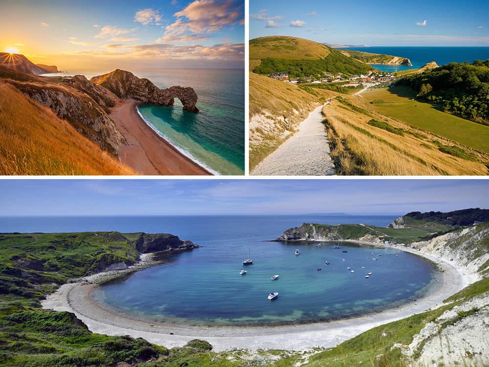
Lulworth Cove, Durdle Door & White Nothe
Follow ancient paths along this stunning sweep of the Jurassic Coast taking in some of the region’s most celebrated natural landmarks
Duration: 3 hours
Terrain: Some steep terrain
Distance: 7-mile loop (Map)
Dog-friendly: ✔
Views of the turquoise waters of Lulworth Cove, encapsulated by its clam-shaped shoreline, follow you along the upwinding path as it undulates the limestone cliffs to the Isle of Portand. Ahead lies the grassy brow of Bindon Hill, and the remains of the ramparts of an Iron Age hillfort. Steps lead you down to Man o’ Way Cove, named after the narrow, Portland stone reef lying just offshore. Around the headland stands the magnificent Durdle Door, a giant natural limestone arch cleaved by the sea 140 million years ago and reportedly the most photographed landmark in Dorset. Between Durdle Door and Bat’s Head, you’ll encounter the chalk-dry, clifftop valley affectionately known as “Scratchy Bottom”, a location used to open the 1967 film adaption of Thomas Hardy’s novel Far from the Madding Crowd.
Breaching the swells and marking what was once the ancient coastline of 10,000 years ago, the rocks known as the Bull, the Blind Cow, the Cow and the Calf, can be seen jutting out from the sea as you traverse the South West Coast Path towards Swyre Head, peppered by holes where cycad trees once grew 147 million years ago. Keep your eyes peeled for stonechats and linnets singing in the furze, and peregrine falcons diving at breakneck speeds overhead. The trail will guide you to the White Nothe headland, another of this sweep’s far-reaching vantage points with views towards the port town of Weymouth.
Doubling back, you’ll reach the Daggers kissing gate which leads you inland along the Ridgeway Path. Here you’ll pass the stone shells sculpted by Peter Randall Page in celebration of the Celtic field system. Fork right onto the footpath, headed to Newlands Farm, crossing the fields to eventually join the track for “Beach Car Park” and the pastures leading back into West Lulworth and your journey’s end. Dogs are allowed on the beaches of Durdle Door and Lulworth Cove throughout the year.
Isle of Portland
Joined to the mainland by a shingle ridge known as Chesil Beach, this enchanting isle is characterised by rugged bluffs, smugglers’ coves and natural wonders.
Duration: 3.5 hours
Terrain: easy-going
Distance: 13-mile loop (Map)
Dog-friendly: ✔
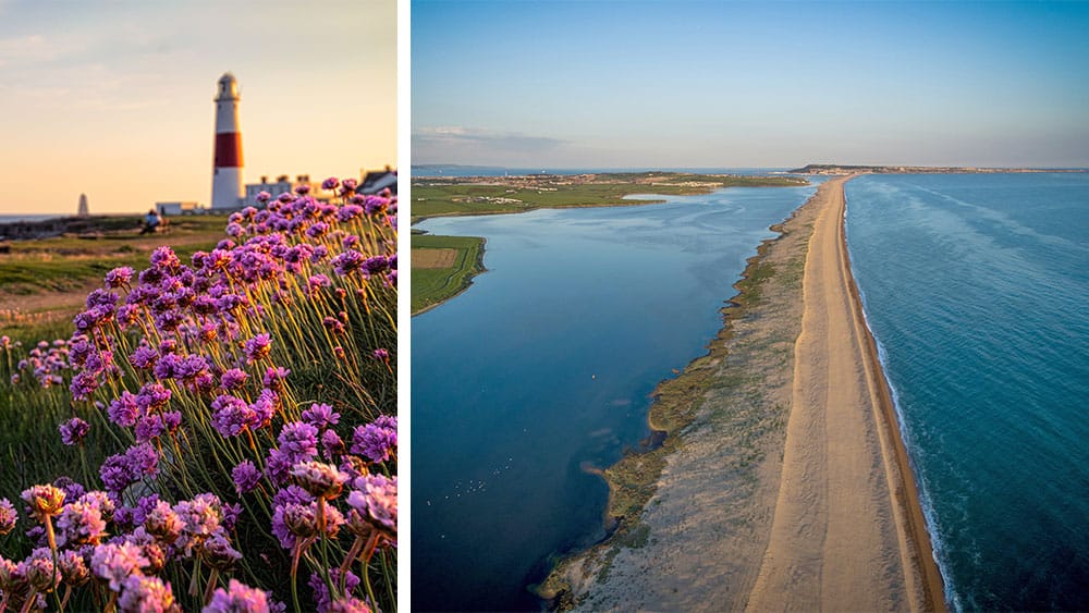
Enjoy an exhilarating walk around this captivating, tied island which thins down into Portland Bill, Dorset’s most southerly point. Dug by the Romans, Portland limestone continues to be quarried and used worldwide, helping to underpin such architectural feats as the vaults and crypts of St Paul’s Cathedral. Today, many of the disused quarries have been reclaimed by nature, filled with wildflowers and grasses. You can walk to the island by way of Chesil Beach or cross the Ferry Bridge and the Fleet Lagoon (the largest tidal lagoon in Britain) from Wyke Regis, following the road or cycle way.
On a clear day, from Pulpit Rock and Portland Bill, you can gaze along the coastline as far as Devon’s Start Point. However, we know that many of you have enjoyed the wild thrill of watching ferocious seas crashing against the Portland rocks. Whether you find yourselves transfixed by the Spirit of Portland sculpture – a tribute to the island’s industrial heritage – or zooming in on the guillemots, fulmars and kittiwakes that inhabit these rocky shores – this exciting circular walk will have you riveted at every turn.
Smuggler’s Inn
Soaring cliffs, shingle sweeps and woodland trails await as you unlock the geological secrets of this prehistoric coastline.
Duration: 2 hours
Terrain: Undulating (sometimes muddy)
Distance: 4.7-mile loop (Map)
Dog-friendly: ✔
Amateur fossil hunters will savour this fossil-rich stroll along shingle strands and undercliffs. The trail takes in a variety of wildlife habitats, starting with Osmington Mills, a magnificent stretch of the Jurassic Coast where cliffs reveal Corallian rocks of the Middle Jurassic and stunning formations of Osmington Oolite limestone, which, over time, has spilled onto the foreshore to reveal its fossilised secrets. The rainbow lustre sometimes seen here on the sea is formed by oil leaked from large Bencliff Grit boulders, also known as “doggers”.
The walk begins at the seaside hamlet of Osmington Mills , home of the Smugglers Inn, the former stronghold of the notorious French smuggler Pierre Latour, known locally as “French Peter”. Follow the coast path past the remnants of a coal barge called the Minx, one of many vessels to have met their fate along these perilous reefs. At the shingles of Ringstead Bay, the trail branches inland towards woodland, bound for the chalky cliffs of White Nothe. The path winds its way above Burning Cliff, site of a smouldering oil-shale fire ignited by a landslip in 1826. You’ll encounter a wooden church before tracking on the rises of the South Down and skirting the heathland to Glebe Cottage, a former chapel that once served the abandoned village of West Ringstead during the Middle Ages. Look out for the road back to Osmington Mills, hopping the stile to pick up a path back to the hamlet.
Take a look at our collection of holiday cottages in Dorset, pack your walking boots and we look forward to hearing which one of these five fabulous walks is your favourite.